Warm weather expected for the holiday season
December 7, 2016
If you’re dreaming of a white Christmas, it looks like you’re out of luck.
Or at least, that’s what the National Oceanic and Atmospheric Administration seems to suggest in its annual winter outlook.
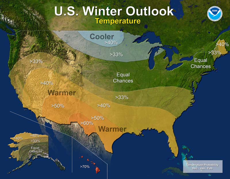
The outlook, which is a climate forecast covering meteorological winter (the months of December, January and February) gives the New Orleans area between a 40 and 50 percent chance of having a warmer than average winter.
The prediction cites a La Nina pattern forming as the primary reason for the increased chances of warm temperatures throughout the South. La Nina occurs when the waters of the eastern Pacific become cooler than normal. Through a complex method of global heat distribution, this pattern has major impacts on global climate, with the primary influence in eastern North America being warmer than average sea surface temperatures in the Atlantic and related bodies of water, such as the Gulf of Mexico.
With a weak La Nina pattern in place, which NOAA officially declared on Nov. 10, its formation “will likely contribute to drier and warmer weather in the Southern U.S. and wetter, cooler conditions in the Pacific Northwest and across to the northern tier of the nation this winter,” according to NOAA.
While NOAA may have that prediction officially in place for this winter, at least in recent years, the actual outcomes appeared very different.
For its 2015-16 winter prediction, NOAA put the New Orleans area in the 40 to 50 percent higher than average likelihood for a cool winter. The high on Christmas this past season: 82, the hottest temperature ever seen on the holiday since record keeping began in 1871.
The previous winter, 2014-15, had a similar result. That winter forecast, too, put the New Orleans area in the 40 to 50 percent likelihood of having a cooler than normal winter.
What happened?
January of 2015 was the warmest January on record at New Orleans International Airport, the site of official weather recording in the city since 1946, with an average temperature of 64.6, far ahead of the previous mark of 63.3, which occurred in 1971.
Look another year in the past, and you find yet another inaccurate prediction. This time going in the opposite direction.
For the 2013-14 season, NOAA gave the New Orleans area a 40 to 50 percent chance of a warmer than average winter.
That winter ended up being the 13th coldest for the state of Louisiana in the 119 years of record keeping, with the city of New Orleans experiencing several hard freezes and ice events, including two incidents of freezing rain occurring in less than a week in January 2014, precipitation that is an extreme rarity in the area.
Barry Keim, Louisiana State University climatologist, recognizes the recent inaccuracies, but feels that since the forecast doesn’t actually predict the temperature, but rather the likelihood of what the temperature might be, the public should take that into consideration.
“The way these things work is that they basically divide things into three groups: it’s either going to be above normal, below normal or somewhere in between,” Kiem said. “So when they put these maps out, and they bump something up to 40 percent or 50 percent, what that’s telling us is that rather than having a one in three chance, you have a one in two chance if it’s 50 percent. I think that most people, when they look at these things, they’re hard to interpret.”
Even with this, though, Keim feels that climatology has not yet reached the point to where these types of forecasts can be trusted.
“The bottom line is that this long-range forecasting does leave a bit to be desired. You know, we’re only so good at it, and that’s why we put these percentiles on it. These indicators tell us a little but about what the future may hold, but in reality, it could be almost anything,” Keim said.
Even after giving these forecasts disclaimers, though, Keim did feel pretty comfortable making one prediction about this winter.
“You know given the dry forecast, I would say the chances are less likely [of seeing any snow] than a typical winter,” Keim said. “Doesn’t mean it won’t happen, but even in an average winter the chances are pretty low, and we’re even lower than that going into this winter. I certainly wouldn’t count on that.”
New Orleans last experienced accumulating snowfall on Dec. 11, 2008.


